21 Best Fall Hikes in Colorado From Easy to Challenging

The best fall hikes in Colorado obviously offer incredible leaf-peeping, but that’s just the beginning. From tunnels of aspens to multi-tiered waterfalls and pristine alpine lakes, we tapped several locals to compile this list of Colorado fall hikes. We PROMISE it isn’t the same ol’ guide with 10 hikes you’ve seen dozens of times!
Fall hiking in Colorado is nothing short of magical, with golden groves of aspen trees, snow dusting the higher elevations, that distinctive crisp mountain air, and increased wildlife sightings.
I lived in Colorado Springs for a few years and still visit the Centennial State two or three times a year…and always fit in at least a few hikes! Using my first-hand experience, plus recs from some friends who are Colorado natives, I put together this ultimate list of fall hikes in Colorado.
You’ll find a handful of bucket list trails, the ones everyone has on their radar, but you’ll also find a bunch of hidden gems even some Coloradans may not know about (really!).
Whether you’re a seasoned hiker or just starting out, a local or visiting, this guide truly has something for everyone—and trust me, I don’t love that cliche saying.
Tip: We included a ton of extra info about fall hiking in Colorado, in addition to specific trails. Exactly when to head out for peak color, tips on acclimating to altitude, what to wear, and more. Use the Table of Contents below to jump directly to (or skip!) a specific section.
This post contains affiliate links. I may receive a small commission — at no cost to you — if you click or make a purchase through any of them. For more information, read my disclosure statement. I appreciate you!
Jump ahead to:
- When Exactly is the Best Time for Fall Hiking in Colorado?
- Tips for Acclimating to High Altitude
- Best Fall Hikes in Colorado: Easy Trails
- 1. Loveland Pass Lake, Keystone
- 2. Maroon Bells Scenic Loop Trail, Aspen
- 3. Aspen Alley, Breckenridge
- 4. Rainbow Gulch Trail, Woodland Park
- 5. Tenderfoot & Oro Trail Loop, Dillon
- 6. Rainbow Lake, Miners Creek & Peaks Trail Loop, Frisco
- 7. Ouzel Falls, Rocky Mountain National Park (Wild Basin Trailhead)
- 8. Cheesman Ranch Trail, Mueller State Park (Divide)
- 9. Judd Falls, Crested Butte
- Moderate Colorado Fall Hikes
- 10. Emerald Lake, Rocky Mountain National Park (Bear Lake)
- 11. Browns Creek Falls, Buena Vista
- 12. Panorama Point via Mule Deer and Raccoon Trail, Golden Gate Canyon State Park
- 13. Upper Piney River Falls, Vail
- 14. Beckwith Pass, Crested Butte
- 15. Burning Bear Trail, Guanella Pass
- 16. Booth Creek Falls (AKA Booth Falls), Vail
- 17. Thunderhead Trail, Steamboat Springs
- Challenging Colorado Fall Hikes
- Tips + Gear Recs for fall Hiking in Colorado
When Exactly is the Best Time for Fall Hiking in Colorado?
As a (very) general rule, the third and fourth week of September are usually pretty solid for leaf-peeping almost anywhere in the state. However, there are several potential exceptions.
First, summer weather is a major factor in the timing and duration of fall. If it was a particularly dry summer, fall is often irregular—super short, a bit early, or very late. A very wet summer can have the opposite, or even similar, effects, completely changing the way the season unfolds.
The next thing to consider is the elevation of Colorado fall hikes. Autumn starts at higher elevations and works its way downward. Similarly, color change starts sooner the further north you are in the state.
So for example, Steamboat Springs and Rocky Mountain National Park typically peak when areas further south, like the San Juans, are just starting to change, even at similar elevation.
Also, the higher the elevation, the shorter the season. If you’re planning to do any high-elevation fall hiking in Colorado, not only will that be a bit earlier in the season, you’ll also need to be ready to go pretty much as soon as you hear the area’s peaking.
One storm or strong weather pattern can (and often does!) literally roll in and blow ALL the leaves off of trees in an entire area overnight.

2025 Peak Fall Color Predictions
Every year, local news stations, hiking and community groups on social media, and even real estate agents and other businesses put up leaf-peeping countdowns and predictions. Look for these around the same time that pumpkin patches in North America start to pop up.
Weather people tend to be almost alarmingly accurate, so they’re probably the most reliable local source. Also, this interactive map was originally designed just for the Smokies, but now covers the entire US with excellent accuracy.
In 2025, here’s what you can safely plan your Colorado fall hiking around.
- September 23 – October 5: Summit County, Vail, Grand Mesa, Gunnison
- September 25 – October 8: RMNP, Steamboat Springs, Western Slope, northern peaks
- September 27 – October 17: San Juans including Durango, Sangre de Cristos
- 1st-2nd week of October: Foothills (Denver, Colorado Springs, and Boulder) and southern Colorado
Tips for Acclimating to High Altitude
Altitude sickness is very real, and can hit especially hard for people who live at or near sea level. The good news? There are several ways to minimize and even prevent the effects so you can fully enjoy fall hiking in Colorado.
- Hydrate, hydrate, hydrate. Start drinking extra water a few days before your trip and continue the habit during your visit. Aim for about twice as much as normal.
- Build in a rest day. If possible, spend a day or two nearby before any intense hikes. Even if you can’t, build up to bigger trails by tackling a couple smaller ones first.
- Take it slow. Ascending too quickly or too far is a top cause of altitude sickness. Along the same lines, take on slightly less challenging hikes—five miles and 600 feet of elevation gain at home is very, very different in Colorado.
- Avoid alcohol. Not only does it dehydrate you, but it’s proven that the body can’t process it very efficiently at high elevations, making altitude sickness worse.
- Fuel up on potassium-rich foods. Hiking snacks like bananas, granola, dried fruit, and celery replenish electrolytes and maintain energy levels.
- Know the signs. Headaches, dizziness, and feeling weak all indicate altitude sickness—listen to your body, rest and have a snack, and descend immediately if you notice severe symptoms including blurred vision, disorientation, or nausea.

Best Fall Hikes in Colorado: Easy Trails
Want the most bang for your buck this leaf peeping season? Many of the best easy fall hikes in Colorado are short enough that you can knock out more than one in a day.
Bonus: these are all excellent hikes to get acclimated to the high altitude.

1. Loveland Pass Lake, Keystone
- Distance: 0.8-mile lollipop loop
- Starting elevation: 11,834 feet
- Elevation gain: 80 feet
- Difficulty rating: Easy
- Dog-friendly? Yes
- Facilities: None
- Alltrails trail notes
In an area famous for epic peak summits, Loveland Pass Lake is a family-friendly gem among Colorado fall hikes. It’s almost unheard of to get these types of jaw-dropping alpine views for so little effort in the Front Range!
The trail follows one side of crystal-clear Pass Lake, then winds around two smaller lakes, all hemmed in by craggy peaks. With almost no elevation gain and dramatic scenery over the Continental Divide, this is a must for anyone.
Although this hike is more like a leisurely stroll, the high elevation makes it tougher than you may think!
What’s nearby: The ski resort town of Keystone is not even 30 minutes away. Grab coffee OR a beer (or both!) at Steep Brewing & Coffee.

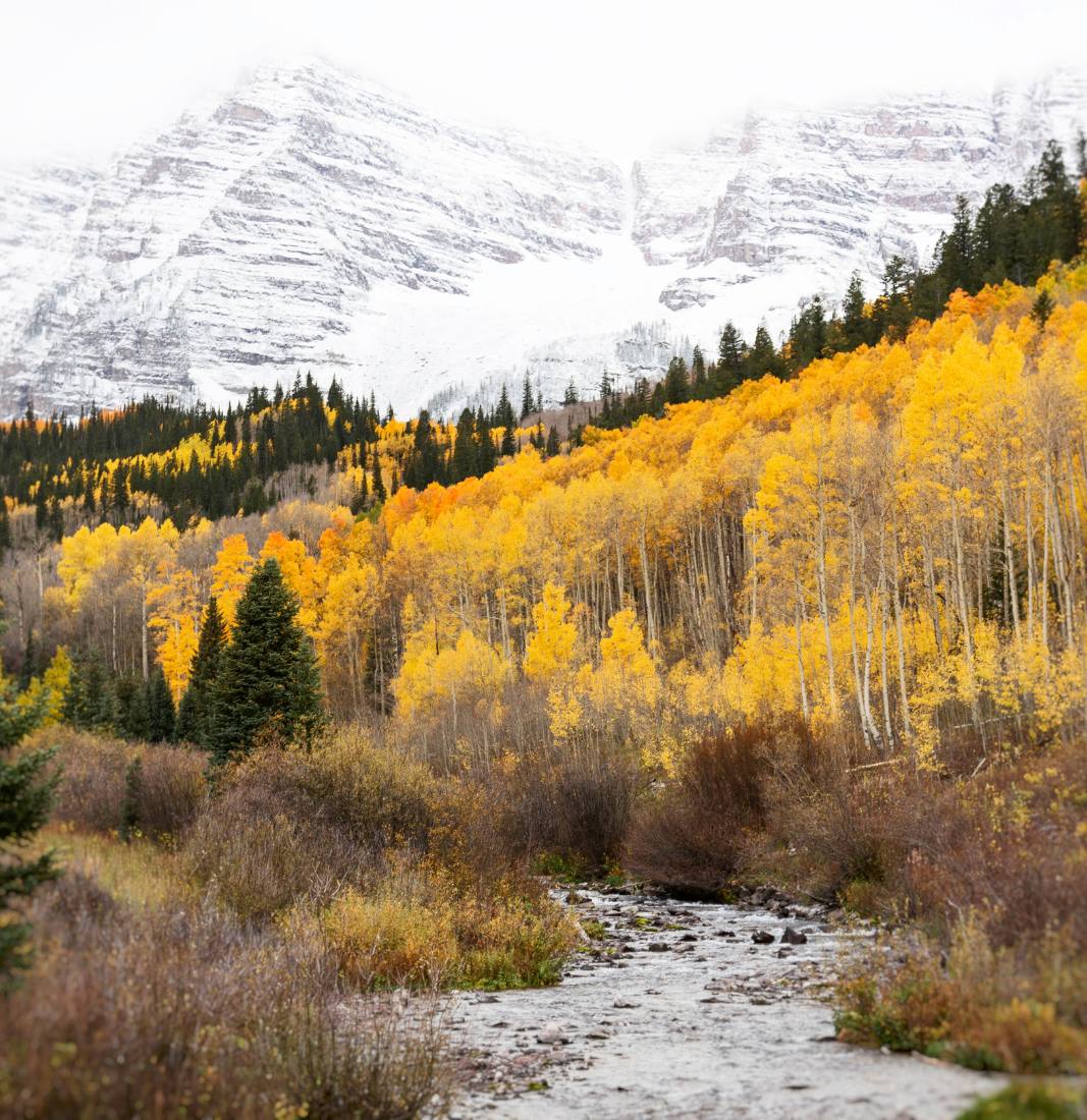
2. Maroon Bells Scenic Loop Trail, Aspen
- Distance: 1.9-mile loop
- Starting elevation: 9,500 feet
- Elevation gain: 160 feet
- Difficulty rating: Easy
- Dog-friendly? No
- Facilities: Restrooms in the parking lot
- Alltrails trail notes
The Maroon Bells are supposedly the most photographed mountains in all of North America. So it comes as NO surprise that they’re home to one of the best fall hikes in Colorado.
With picture-perfect views of the Bells reflecting off crystal-clear Maroon Lake, the Scenic Loop Trail is an easy, flat loop that winds through meadows along the creek and past an active beaver dam.
Unsurprisingly, the Maroon Bells is such a popular area that you need a permit for access through the end of October (more on that below!).
Those looking for more of a challenge (and slightly fewer crowds) can continue on to Crater Lake. The trail goes about three-quarters of a mile past where the Scenic Loop turns around, making it a 3.5-mile round trip.
From May 15-October 31, all visitors must have a reservation for the Maroon Bells Scenic Area (not only is it one of the most popular Colorado fall hikes, it’s spectacular during wildflower season, too!). Choose from a trailhead permit to park your own vehicle, or RFTA shuttle reservations.
- Maroon Bells private vehicle trailhead parking permits: $10 per vehicle, MUST arrive before 8:00 am or after 5:00 pm unless you have an overnight wilderness camping permit
- RFTA shuttle: Runs May 24-October 20 7:00 am to 3:00 pm (one-way rides from Maroon Lake until 5:00 pm), $10-16 per person, departing from Aspen Highlands. Paid parking at Aspen Highlands, or park at the Brush Creek Park & Ride and take a free shuttle to the Highlands.

3. Aspen Alley, Breckenridge
- Distance: 3 miles out-and-back
- Starting elevation: 9,720 feet
- Elevation gain: 520 feet
- Difficulty rating: Easy to Moderate
- Dog-friendly? Yes
- Facilities: None
- Alltrails trail notes
Aspen Alley is one of the best fall hikes in Colorado because, as its name implies, the trail is literally surrounded by aspens. With the only exception being the final section near the top, you walk through a golden ‘tunnel’ practically from start to finish.
It’s especially important to stay alert on this trail, because Aspen Alley is wildly popular with mountain bikers and people hiking with dogs.
To do this as an out-and-back hike, start at the Breckenridge Sawmill Museum. You’ll start to climb almost immediately, but it’s a gentle grade minimized by a series of switchbacks.
Want to make the Aspen Alley hike even easier? Do the downhill only. Take the FREE Summit Stage bus to the top, then simply walk down. You want the Boreas Pass Loop (pink), which runs every 30 minutes all day (hourly after November 1). Get off at the Lucky, Gold Point, or Overlook stops.
What’s nearby: The OG Breckenridge Brewery (you know, the one that makes the iconic Vanilla Porter) is a three-minute drive from the trailhead.

4. Rainbow Gulch Trail, Woodland Park
- Distance: 3.5 miles out-and-back
- Starting elevation: 9,200 feet
- Elevation gain: 280 feet
- Difficulty rating: Easy
- Dog-friendly? Yes
- Facilities: None, but there are vault toilets at Promontory Picnic Area on the reservoir
- Alltrails trail notes
One of the truly easy Colorado fall hikes on our list, Rainbow Gulch is ideal for families with young kids and people who don’t necessarily consider themselves hikers.
The wide, flat trail leads gently down to Rampart Reservoir, passing several stands of aspens and following a creek in the woods before the view opens up. Once at the lake, you can picnic or fish (bring a rod!), but you cannot swim, wade, or even dip your feet in.
Reminiscent of a Thomas Kinkade painting, fall scenery here is dreamy and cast in a soft glow. Look for the huge, house-sized boulders just off the trail, which are particularly fun for kiddos.
Even the drive to the trailhead is gorgeous. It’s about 45 minutes northwest of Colorado Springs, and you’ll enjoy spectacular views of Pikes Peak throughout.
Up for a longer, but still easy hike? Continue around the reservoir for as long as you like; a trail completely circles it, forming an 11-mile loop.
What’s nearby: Not technically ‘nearby,’ but coming from Colorado Springs, you’ll pass right by Garden of the Gods, Manitou Springs, and the North Pole Santa’s Workshop. Lots of fun options to extend your adventure!

5. Tenderfoot & Oro Trail Loop, Dillon
- Distance: 3-mile loop
- Starting elevation: 9,280 feet
- Elevation gain: 520 feet
- Difficulty rating: Easy to Moderate
- Dog-friendly? Yes
- Facilities: None
- Alltrails trail notes
The Tenderfoot-Oro Trail Loop is a gem for fall hiking in Colorado—short, sweet, and just 1.5 hours from Denver in Summit County. As you gradually ascend Tenderfoot Mountain, you’ll be treated to panoramic views of Dillon Reservoir and the Tenmile Range.
What makes this one of the best fall hikes in Colorado, though, are the stands of aspens and lodgepole pines along the trail. The striking gold against the lake’s sapphire blue is an unforgettable sight! Pro tip: go clockwise (left when you start on the trail) for the best views.
This trail is particularly popular with cyclists and trail runners, so share the trail and keep your eyes and ears open for mountain bikes.
What’s nearby: The Baja Fish burrito at Chimayo Grill is transformative.

6. Rainbow Lake, Miners Creek & Peaks Trail Loop, Frisco
- Distance: 4.8-mile loop
- Starting elevation: 9,100 feet
- Elevation gain: 600 feet
- Difficulty rating: Easy to Moderate
- Dog-friendly? Yes
- Facilities: None
- Alltrails trail notes
This local favorite loop trail proves you don’t have to leave town to enjoy some of the best fall hiking in Colorado. The Rainbow Lake trailhead is minutes from charming downtown Frisco—a 15-minute walk from Main Street!
You’ll enjoy a lot of variety on this great hike: boardwalk paths over wetlands, bridges, fall colors, streams, beaver ponds, meadows, and likely, wildlife sightings. Look for moose and deer in the meadows!
Rainbow Lake is not even a mile in, so the first part of the trail is typically pretty busy. Once you pass it, though, you’ll leave any crowds behind.
What’s nearby: If you’re feeling extra motivated, stay on the Peaks Trail to hike all the way to Breckenridge (about eight miles each way)! For us non-maniacs out there just looking for a post-hike snack, head to Butterhorn Bakery and get the massive grilled cheese with bacon.

7. Ouzel Falls, Rocky Mountain National Park (Wild Basin Trailhead)
- Distance: 5.4 miles out-and-back
- Starting elevation: 8,566 feet
- Elevation gain: 980 feet
- Difficulty rating: Easy to moderate
- Dog-friendly? No
- Facilities: Restroom at the trailhead
- Alltrails trail notes
Ouzel Falls is a fantastic choice for fall hiking in Colorado, offering a beautiful contrast between the multiple waterfalls, enormous boulders, and vibrant autumn scenery.
As a bonus, it’s also widely considered one of the best easy hikes in Rocky Mountain National Park.
Along the trail, you’ll come to three smaller waterfalls before reaching 40-foot Ouzel Falls: Copeland Falls (Upper and Lower), not even a half-mile in, then Calypso Cascades.
Insider tip: once the trail ‘officially’ ends at Ouzel Falls, look for a social trail just before the bridge to get up above the cascade for an even better view.
Once Old Man Winter arrives (which can be as early as October!), hikers will have to park in the winter lot for Wild Basin hikes, adding 3.5 miles each way.

8. Cheesman Ranch Trail, Mueller State Park (Divide)
- Distance: 5.25-mile loop
- Starting elevation: 9,600 feet
- Elevation gain: 700 feet
- Difficulty rating: Easy to moderate
- Dog-friendly? No
- Facilities: Restrooms and water fountains at park visitor center
- Alltrails trail notes
This peaceful, rolling hiking trail in hidden-gem (i.e., rarely crowded) Mueller State Park goes past the historic Cheesman Ranch homestead, through meadows, and into aspen groves.
Enjoy outstanding views of Pikes Peak from the meadows, and keep your eyes open for mule deer, elk, and even black bears. Abundant wildlife is one of the things that makes this one of the best fall hikes in Colorado.
You’ll finish the loop on an incline either way, but going counter-clockwise lets you avoid steeper elevation gain on the way back.
What’s nearby: The historic mining town of Cripple Creek is close by, one of only three towns statewide (!!) with casinos. And if you’re up for more fall hiking in Colorado, the Rainbow Gulch Trail (#4 on this list) is about 35 minutes away.

9. Judd Falls, Crested Butte
- Distance: 2.2 miles out-and-back
- Starting elevation: 9,500 feet
- Elevation gain: 460 feet
- Difficulty rating: Easy to moderate
- Dog-friendly? Yes
- Facilities: Restrooms in the upper parking lot
- Alltrails trail notes
Judd Falls is deservedly one of the most popular hikes near Crested Butte, with its short distance and gorgeous scenery year-round. Don’t let that deter you—outside of wildflower season, Crested Butte is rarely busy.
The hike starts out on a wide dirt road through dense aspens, then narrows and gets rockier and a bit trickier to navigate close to the waterfall. You’ll end at a bench overlooking Judd Falls, beautifully framed by rocky cliffs and pops of gold in the fall.
The upper parking lot is accessible only with 4-wheel-drive. All other vehicles can park in the lower lot (Copper Creek), but note that it will add about half a mile to your total distance each way (one mile round trip).
What’s nearby: The ghost town of Gothic is just below the trailhead. And be sure to spend some time strolling Elk Avenue in pedestrian-friendly Crested Butte. We love adorable Camp 4 Coffee!
Moderate Colorado Fall Hikes
This section with moderate and slightly more challenging trails has several local-favorite hikes. That includes some ‘secret’ trails mixed in with the ones inside well-known national and state parks.

10. Emerald Lake, Rocky Mountain National Park (Bear Lake)
- Distance: 3.2 miles out-and-back
- Starting elevation: 9,475 feet
- Elevation gain: 700 feet
- Difficulty rating: Moderate
- Dog-friendly? No
- Facilities: Restrooms in the parking lot
- Alltrails trail notes
RMNP’s Emerald Lake offers a slightly different experience among Colorado fall hikes. Most of the year, the distinct green lake is one of the most popular places in the entire park.
But unlike more densely forested areas, the Emerald Lake trail has fewer trees that lose their leaves, making it less of a leaf-peeping hotspot. That means it’s a bit less crowded in September and October (manage expectations here; this is still one of the busiest national parks!).
So although you won’t see big, bright splashes of yellow, this is one of the best fall hikes in Colorado for enjoying a rare quieter side of the season.
The hiking trail starts at Bear Lake and climbs up past Nymph Lake and Dream Lake before reaching namesake Emerald Lake. Without the usual throngs of people, you’ll be able to soak in views of Hallett Peak (and not have to wait your turn for photos!).
What’s nearby: Tour the allegedly haunted Stanley Hotel and eat, drink, and shop your way through Estes Park. Antonio’s Real NY Pizza is a must. Whatever you do, watch for elk…they’re everywhere!

11. Browns Creek Falls, Buena Vista
- Distance: 5.7 miles out-and-back
- Starting elevation: 8,913 feet
- Elevation gain: 930 feet
- Difficulty rating: Moderate
- Dog-friendly? Yes
- Facilities: Pit toilet at the trailhead
- Alltrails trail notes
With a nice variety of scenery and a mix of aspens and pines, Browns Creek Falls is one of the best fall hikes in Colorado. The trail meanders alongside Browns Creek most of the way, starting and ending in a dense forest and traveling through an open meadow toward the end.
Most of the elevation gain is in the first mile of the trail (you’ll know, trust us!), but it levels out after that.
There are multiple creek crossings, the first one 1.65 miles in. Like most fall hiking in Colorado, water levels are significantly lower this time of year, but in the summer, the creek gushes and there are smaller waterfalls along the trail.
Just shy of the 3-mile mark, look out for the tiny wooden ‘FALLS’ sign. It’s easy to miss!
What’s nearby: Grab cannoli and/or lunch from Sorelle Delicatessen, drive Cottonwood Pass, and indulge in a relaxing soak at Mount Princeton Hot Springs in nearby Nathrop.

12. Panorama Point via Mule Deer and Raccoon Trail, Golden Gate Canyon State Park
- Distance: 5-mile loop
- Starting elevation: 9,120 feet
- Elevation gain: 1,020 feet
- Difficulty rating: Moderate
- Dog-friendly? Yes
- Facilities: Restrooms and picnic area at Panorama Point
- Alltrails trail notes
45-ish minutes from Denver and offering excellent views of the Front Range, Golden Gate Canyon State Park has some of the best fall hikes in Colorado.
This particular loop to Panorama Point takes the Mule Deer and Raccoon trails, weaving through groves of aspen trees and mixed-pine forest. Other than a few steep sections, the trail mostly has a manageable, gradual ascent.
The real reward comes at Panorama Point, where you’ll find a large viewing deck showing off snow-capped Front Range peaks.
Want something a bit shorter and easier? Try the Racoon Loop, starting from Reverend’s Ridge Campground. You’ll still hike to Panorama Point, but It’s just 2.5 miles round trip.
What’s nearby: Tiny Nederland (‘Ned’) is just 20 minutes away. Get post-hike pizza at Crosscut Pizzeria & Taphouse and browse the banned book section at Blue Owl Books.

13. Upper Piney River Falls, Vail
- Distance: 6 miles out-and-back
- Starting elevation: 9,365 feet
- Elevation gain: 400 feet
- Difficulty rating: Moderate
- Dog-friendly? Yes
- Facilities: None
- Alltrails trail notes
This truly moderate hike starts at Piney Lake near privately-owned Piney River Ranch, taking you along the Piney River and offering great views of the rugged Gore Range. It’s one of the best fall hikes in Colorado scenery-wise, as golden aspens literally cover the hillsides.
As a HUGE bonus, Vail tends to be far less crowded than Summit County, despite being just a bit further up I-70!
The first part of the trail takes you gently through meadows (look for moose!). Once you enter aspen groves, you’ll start to climb and the trail becomes noticeably rougher and more rocky.
Just under the three-mile mark, you’ll be rewarded with a view of Piney River Falls tumbling down a rocky ledge.
The most challenging part of this hike is likely the drive to the trailhead. It’s manageable for even small cars, but it’s slow-going, 40-45 minutes down a dirt road.
What’s nearby: Vail is a great town, even in the off-season—and especially for foodies. Check out the Vail Farmers Market on Sundays and Thursday nights through early October, and grab breakfast or lunch at family-owned The Little Diner.

14. Beckwith Pass, Crested Butte
- Distance: 6.4 miles out-and-back
- Starting elevation: 9,600 feet
- Elevation gain: 885 feet
- Difficulty rating: Moderate
- Dog-friendly? Yes
- Facilities: Vault toilets and water in Lost Lake Campground
- Alltrails trail notes
For people willing to take a bit of a (very scenic) road trip to ditch the crowds, fall hiking in Colorado doesn’t get much better than Beckwith Pass. The drive in is phenomenal, taking you on Gunnison County Road 12—AKA Kebler Pass.
This moderate trail descends and ascends through thousands of aspens, then meanders through open fields and mixed spruce forest, involving up to a dozen easy creek crossings. Although the trail goes steadily uphill, it’s gradual, with a 2% average grade.
Once you make it to the end of the trail, it’s worth going a bit further to see the unique views from the other side of the pass.
It’s also worth camping overnight in this area, especially since it’s a bit of a trek from, well, anywhere. Lost Lake Campground, where the trailhead starts, closes for the season the first week of October, but there’s tons of dispersed camping nearby.
Insider tip: Fall foliage season aligns with Colorado’s hunting season, and this hike is in the West Elk Wilderness—where hunting is allowed. Wear bright colors so hunters can see you.

15. Burning Bear Trail, Guanella Pass
- Distance: 7.5 miles out-and-back
- Starting elevation: 9,620 feet
- Elevation gain: 1,250 feet
- Difficulty rating: Moderate
- Dog-friendly? Yes
- Facilities: None
- Alltrails trail notes
While Guanella Pass is home to some extremely popular Colorado fall hikes like Silver Dollar Lake and Murray Lake, Burning Bear is a quieter alternative. The scenic trail winds through meadows, alongside a creek, through aspens, and past the remains of a historic cabin.
Start at the Geneva Creek Trailhead in the Abyss Lake parking lot. The first mile or so is fairly flat, traveling through a wide open meadow between the creek and the edge of the forest. This section of the trail has some of the best views, and is also prime moose territory.
After weaving in and out of the trees, you’ll come to the old cabin at 2.5 miles in. From there, the trail climbs significantly, switchbacking up the ridge to the ‘summit.’
The reason ‘summit’ is in quotation marks? It’s not at all a traditional summit, surrounded by taller peaks and trees that obstruct the view. This is likely the reason Burning Bear is less busy than other Guanella Pass hikes, but it’s a great trail specifically for leaf-peeping.
IMPORTANT: Burning Bear has two trailheads, east and west. The one we detail here (by far the more popular option) is the east trailhead, which starts at the Abyss Lake parking lot. The west trailhead can only accommodate 2-3 vehicles.

16. Booth Creek Falls (AKA Booth Falls), Vail
- Distance: 3.9 miles out-and-back
- Starting elevation: 8,461 feet
- Elevation gain: 1,300 feet
- Difficulty rating: Moderate to challenging
- Dog-friendly? Yes
- Facilities: Porta-potties at the trailhead summer through fall
- Alltrails trail notes
Minutes from the state’s biggest ski resort (by a LOT, if you’re wondering), you’ll find one of the best shorter Colorado fall hikes. Less than two miles each way, Booth Creek Falls is easily doable as a half-day trip from Denver.
The hike starts in a dense aspen forest that turns brilliant yellow in late September, creating a tunnel of golden leaves. As you climb uphill, the first mile and last stretch are especially steep, but the scenery over the Gore Range offers a welcome distraction.
Insider tip: It’s easy to miss the waterfall. When you reach Booth Falls, you’ll be standing on top of it. Carefully approach the cliff edge to see the 60-foot fall and river.
17. Thunderhead Trail, Steamboat Springs
- Distance: 6.6 miles out-and-back
- Starting elevation: 6,900 feet
- Elevation gain: 2,200 feet
- Difficulty rating: Moderate to challenging
- Dog-friendly? Yes
- Facilities: Bathrooms and services at Thunderhead Lodge, but not the bottom trailhead
- Alltrails trail notes
Want to experience Steamboat’s iconic ski mountain without skiing? Thunderhead Trail takes you switchbacking up Mount Werner, from base to the summit (which is actually mid-mountain).
You’ll zig-zag over the ski run several times and cross over other trails, so either AllTrails or a paper map are a must. The trail is a mix of dense aspens and exposed sections, so you get the best of fall hiking in Colorado: fiery golden foliage and wide-open mountain views.
On weekends (Friday-Sunday) through September 29, you can hike one direction and take the Steamboat Gondola the other.
For an easy hike, ride the gondola up and hike down. For more of a challenge, hike up, then ride back down to town. Riding up requires a ticket purchase, while riding down is totally free! Also, the gondola is dog-friendly!
What’s nearby: Strawberry Park Hot Springs is just 20 minutes from Steamboat. Reservations required, but well worth it for the unique blend of natural hot springs with developed amenities.
LOVE COLORADO? YOU’LL LOVE THESE STORIES, TOO!
Challenging Colorado Fall Hikes
Want some tougher fall hiking in Colorado? There’s no shortage of trails to choose from! Keep in mind, however, that what Coloradans consider ‘chill’ hikes tend to be fairly strenuous by just about everyone else’s standards—so you may find ‘challenging’ reallyfreakinghard.

18. Hanging Lake, Glenwood Springs
- Distance: 1.3 miles out-and-back
- Starting elevation: 6,380 feet
- Elevation gain: 1,200 feet
- Difficulty rating: Challenging
- Dog-friendly? No
- Facilities: Restrooms, water fountain, and picnic tables at the trailhead
- Alltrails trail notes
Hanging Lake is one of the most iconic hikes in Colorado overall, and it’s even more spectacular in the fall. Located just off I-70 near Glenwood Springs, the trail is short but very steep, with seven bridges and tons of rock steps to navigate. It reminds us a lot of the Mist Trail in Yosemite!
The hike leads to Hanging Lake, crystal-clear, jade green, and seemingly suspended in Glenwood Canyon, the result of a geological fault. Ethereal, wispy Bridal Veil Falls feeds the lake, cascading from the cliffs.
Don’t miss Spouting Rock, a waterfall that shoots straight out of the canyon wall above Hanging Lake. You can even walk right behind the waterfall here!
Thanks to the trail’s lower elevations, Hanging Lake is accessible much later in the season than many other Colorado fall hikes (actually, it’s accessible all year!). Foliage also turns a bit later along the river, so this is a perfect hike for mid- to late October.
Permits are REQUIRED to hike Hanging Lake. As of summer 2024, the trail is also closed Monday-Friday and some weekends for reconstruction. Every Thursday at 9:00 am MDT, limited permits are released for the following weekend.
What’s nearby: Indulge in a soak at the world’s largest hot springs pool. Glenwood Hot Springs Resort is less than 15 minutes from the trailhead.

19. Jud Wiebe Memorial Trail, Telluride
- Distance: 3.1-mile loop
- Starting elevation: 8,754 feet
- Elevation gain: 1,210 feet
- Difficulty rating: Challenging
- Dog-friendly?
- Facilities:
- Alltrails trail notes
Named to honor a Telluride forest ranger credited with many contributions to the city’s excellent network of trails, the Jud Wiebe Memorial Trail is a local favorite among Colorado fall hikes.
Short but steep, it’s perfect for a quick workout without even leaving town. And speaking of town, the views over Telluride, the ski area, and the rugged peaks framing it all are what make this hike a standout.
You can hike either direction, but we recommend clockwise. This gets the steepest, most exposed sections of the trail out of the way early on. Just be aware that the downhill going this direction can be slippery, as it’s covered in loose scree.
What’s nearby: Spend some time wandering around Telluride. We adore Town Park, and Clark’s Market is an absolute gem—a locally-owned market, perfect for hiking snacks and charcuterie.

20. Island Lake & Ice Lake via Ice Lakes Trail, Silverton
- Distance: 6.9 miles out-and-back
- Starting elevation: 9,600 feet
- Elevation gain: 2,650 feet
- Difficulty rating: Challenging
- Dog-friendly? Yes
- Facilities: Pit toilets at the trailhead
- Alltrails trail notes
Although there’s perhaps better fall hiking in Colorado from a foliage perspective, September into early October is the best time to hike Island and Ice lakes.
The trail isn’t quite as busy (to manage expectations, it’s still not a hidden gem, but it’s quiet compared to, say, Blue Lakes, another one of the best fall hikes in Colorado), the bit of color change adds a layer of drama, and you cannot beat the rugged San Juans for scenery.
This hike is tough from start to finish, no question—but so, so worth the effort. Besides the steepness, you’ll be hiking above 10,000 feet the entire time. Both lakes sit above 12,000 feet, so be prepared for any type of weather and afternoon storms any time of year.
While you can hike the loop in either direction, we highly recommend going counter-clockwise, hitting Island Lake first.
Not only does this mean that the entire second half of your hike will be downhill, but it also puts the trail’s best views (hiking down from Island Lake to Ice Lake) in front of you.
Side note: apparently, lots of people skip Island Lake. Don’t do that! It’s honestly not much more effort to visit both lakes, and you will regret not hitting both! With that said, Island Lake is unsurprisingly less busy than Gatorade-blue Ice Lake.
What’s nearby: Silverton is 20 minutes one direction and Ouray is 50 minutes in the other. They’re connected by the most famous stretch of the jaw-dropping Million Dollar Highway (US Route 550), so personally, we always hit both.

21. Berry Picker Trail, Vail
- Distance: 7.9 miles out-and-back
- Starting elevation: 8,150 feet
- Elevation gain: 2,285 feet
- Difficulty rating: Challenging
- Dog-friendly? Yes, but note that dogs can only ride the gondola down
- Facilities: Tons of options in Lionshead Village
- Alltrails trail notes
Literally winding up the slope of Vail Mountain, the Berry Picker Trail is one of our personal favorite more challenging Colorado fall hikes.
Starting at the gondola in Lionshead Village, the trail alternates between wide-open, exposed sections following ski runs and dense forest that provides welcome shade on warmer days.
While you start climbing almost immediately—and never really stop, your efforts are richly rewarded at the summit, with stunning views of the Gore Range and Vail down below. The trail is also never particularly difficult or technical besides being steep.
Note that the first quarter-mile or so of the trail is the toughest. Push through that, and the rest is cake (promise!).
Just like the Thunderhead Trail at Steamboat, you can opt to take the gondola one direction. It’s open Friday through Sunday through September 29, and also like Steamboat, it’s free to download (ride down). The ride up is spendy at about $50 each, however.
Pet parents, take note: dogs can download, but not ride up.
What’s nearby: Vail Brewing Company in Eagle Vail is about 10 minutes from the trailhead, and has a Rocky Mountain Taco truck outside.

Tips + Gear Recs for fall Hiking in Colorado
- Go SUPER early or late in the day. Everyone has the same handful of Colorado fall hikes on their list, and the same idea: start early. To beat the crowds, you have to start really early, so we actually recommend going in the late afternoon.
- Have a firm plan and be ready to go. Decide on your hikes early, then when you hear an area is near or at peak color, head out ASAP. Remember, fall in Colorado is fleeting!
- Ask locals for trail recommendations. Coffee shop baristas, brewery employees, Uber drivers, grocery store clerks…all great sources for asking where locals actually hike.
- Wear or pack layers. Assume the weather will vastly change, quickly, especially above 10,000 feet. We always wear wool socks and bring a mid layer to throw on if we get chilly, plus a packable, hooded rain jacket (the Columbia Switchback III has been our go-to for years).
- If it’s especially cold or wet, consider wearing a moisture-wicking base layer (in a transition season, a top OR bottoms is probably sufficient) and packing a mid-weight puffer like the Patagonia Nano Puff.
- Trekking poles and microspikes are musts. You never know when you might run into early season snow or ice. We LOVE these collapsible (and super affordable!) trekking poles, and these crampons are easy to toss into your bag.
- Don’t forget sun protection. Even if there is snow on the ground and it’s cold, UV rays really are stronger in Colorado and you can 100% burn. Wear sunscreen and bring a hat!
- Bring a headlamp. Fall hiking in Colorado = fewer daylight hours, and it’s always a good idea to have a back-up plan. This is one staple we always keep in our packs anyway, but especially in the fall. We’ve become obsessed with the super light, rechargeable BioLite 325.
- Have a post-hike ‘bundle’ in your vehicle. Pack a change of clothes including socks and clean shoes, plus snacks and extra water. It’s a welcome treat, especially if you’re cold or wet.
